Skip to content
Holopaw, FL

Parcel Search. Suburban Estates

Look up property owners and parcel numbers for all parcels in Suburban Estates, Holopaw, FL. Free. No account required.

Holopaw, FL, Osceola County, FL·~11,000-acre community·Typical lot: 0.3 to 1.25 acres
Showing 8089–8112 of 8,453 parcels
3627316000000L0680JOHNSON RYAN MITCHELLHOLOPAW GROVES RD, SAINT CLOUD3627316000000L0690JONES JAY MHOLOPAW GROVES RD, SAINT CLOUD3627316000000L0691JONES JAY MHOLOPAW GROVES RD, SAINT CLOUD3627316000000L0692JONES JAY MHOLOPAW GROVES RD, SAINT CLOUD3627316000000L0693JONES JAY MHOLOPAW GROVES RD, SAINT CLOUD3627316000000L0700FORMA ANNE JEANHOLOPAW GROVES RD, SAINT CLOUD3627316000000L0711SETR EQUIPMENT LLCHOLOPAW GROVES RD, SAINT CLOUD3627316000000L0712SETR EQUIPMENT LLCHOLOPAW GROVES RD, SAINT CLOUD3627316000000L0713SETR EQUIPMENT LLCHOLOPAW GROVES RD, SAINT CLOUD3627316000000L0720MAHONEY BRIAN JRHOLOPAW GROVES RD, SAINT CLOUD3627316000000L0730GNAP CHRISTOPHER JHOLOPAW GROVES RD, SAINT CLOUD3627316000000L0740GARMANY LINDA MHOLOPAW GROVES RD, SAINT CLOUD3627316000000L0750LEWIN PEARL TRHOLOPAW GROVES RD, SAINT CLOUD3627316000000L0770REID DAMENHOLOPAW GROVES RD, SAINT CLOUD3627316000000L0772REID DAMEN DHOLOPAW GROVES RD, SAINT CLOUD3627316000000L0780ALLEN SCOTT F TRHOLOPAW GROVES RD, SAINT CLOUD3627316000000L0800RIVERA MATOS KIMBERLYHOLOPAW GROVES RD, SAINT CLOUD3627316000000L080ARIVERA HERNANDEZ EDUARDOHOLOPAW GROVES RD, SAINT CLOUD3627316000000L080BCARR ELLA MARGURETTHOLOPAW GROVES RD, SAINT CLOUD3627316000000L080CCARR ELLA MARGURETTHOLOPAW GROVES RD, SAINT CLOUD3627316000000L0810MOYER DARIN JHOLOPAW GROVES RD, SAINT CLOUD3627316000000L0830MAYBERRY KENNETHHOLOPAW GROVES RD, SAINT CLOUD3627316000000L0840SAWICKI MICHAEL RHOLOPAW GROVES RD, SAINT CLOUD3627316000000L0841DIAZ REYES VIVIAN GRIZETTEHOLOPAW GROVES RD, SAINT CLOUD

Page 338 of 353

8089–8112 of 8,453

About Holopaw, FL Parcel Records

Suburban Estates is located roughly 50 miles south of Orlando in Osceola County. The community contains thousands of individual parcels, typically 0.3 to 1.25 acres of raw land.

Parcel data shown here comes from Osceola County public GIS records. You can search by owner name (last name works best) or by parcel number. Each record shows the owner of record, mailing address, physical address, acreage, assessed value, and legal description.

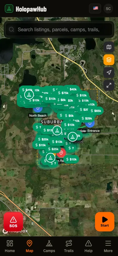
Need to see parcel boundaries on a map? The free Holopaw Hub app shows every parcel boundary overlaid on satellite imagery. Tap any lot to see owner details, record a trail, or check fire alerts. No subscription required.

See every parcel on a satellite map

The Holopaw Hub app shows every parcel boundary on satellite imagery. Tap any lot for owner details, fire alerts, and community features. Completely free.

Get the App. It's Free
In your pocket

Holopaw Hub, in your pocket.

Everything on this site plus the parts that only work in the field: parcel maps, GPS trail recording that keeps going with no signal, the neighbor feed, and fire alerts that reach you before the smoke does.

  • Public-land boundaries in your pocket. No subscription

  • Walk a boundary with GPS and see its real shape

  • Plan the route out to the parcel and save it

  • GPS tracking that keeps recording where signal never reaches

The Holopaw Hub app