Skip to content
Holopaw, FL

Parcel Search. Suburban Estates

Look up property owners and parcel numbers for all parcels in Suburban Estates, Holopaw, FL. Free. No account required.

Holopaw, FL, Osceola County, FL·~11,000-acre community·Typical lot: 0.3 to 1.25 acres
Showing 6961–6984 of 8,453 parcels
31273260002242001MRIESKAMP CYNTHIA LYNNHOLOPAW GROVES RD, SAINT CLOUD31273260002243000MAARON GOLDMAN REVOCABLE TRUSTHOLOPAW GROVES RD, SAINT CLOUD31273260002244000MSUSKIND DENNISHOLOPAW GROVES RD, SAINT CLOUD31273260002311001MLASITTER R W JRHOLOPAW GROVES RD, SAINT CLOUD31273260002311002MALABURDA ANTHONYHOLOPAW GROVES RD, SAINT CLOUD31273260002311003MALABURDA ANTHONYHOLOPAW GROVES RD, SAINT CLOUD31273260002311004MALABURDA ANTHONYHOLOPAW GROVES RD, SAINT CLOUD31273260002311005MALABURDA ANTHONYHOLOPAW GROVES RD, SAINT CLOUD31273260002312001MALABURDA ANTHONYHOLOPAW GROVES RD, SAINT CLOUD31273260002312002MDIAZ ROLON JENNYS MARIEHOLOPAW GROVES RD, SAINT CLOUD31273260002312003MALABURDA ANTHONYHOLOPAW GROVES RD, SAINT CLOUD31273260002312004MALABURDA ANTHONYHOLOPAW GROVES RD, SAINT CLOUD31273260002312005MALABURDA ANTHONYHOLOPAW GROVES RD, SAINT CLOUD31273260002313001MZABIELSKI DAVIDHOLOPAW GROVES RD, SAINT CLOUD31273260002313002MAARON GOLDMAN REVOCABLE TRUSTHOLOPAW GROVES RD, SAINT CLOUD31273260002313003MROCK THOMAS EHOLOPAW GROVES RD, SAINT CLOUD31273260002314000MMIRAGEAS GEORGE G ESTHOLOPAW GROVES RD, SAINT CLOUD31273260002321001MS&I STATES LLCHOLOPAW GROVES RD, SAINT CLOUD31273260002321002MS&I STATES LLCHOLOPAW GROVES RD, SAINT CLOUD31273260002322000MHARP DONNIEHOLOPAW GROVES RD, SAINT CLOUD31273260002322002MBAKER SAMUELHOLOPAW GROVES RD, SAINT CLOUD31273260002323001MCHATHAM KERRY NHOLOPAW GROVES RD, SAINT CLOUD31273260002323002MCRUMLEY DENNY CHOLOPAW GROVES RD, SAINT CLOUD31273260002324000MTURIGLIATTI CHRISHOLOPAW GROVES RD, SAINT CLOUD

Page 291 of 353

69616984 of 8,453

About Holopaw, FL Parcel Records

Suburban Estates is located roughly 50 miles south of Orlando in Osceola County. The community contains thousands of individual parcels, typically 0.3 to 1.25 acres of raw land.

Parcel data shown here comes from Osceola County public GIS records. You can search by owner name (last name works best) or by parcel number. Each record shows the owner of record, mailing address, physical address, acreage, assessed value, and legal description.

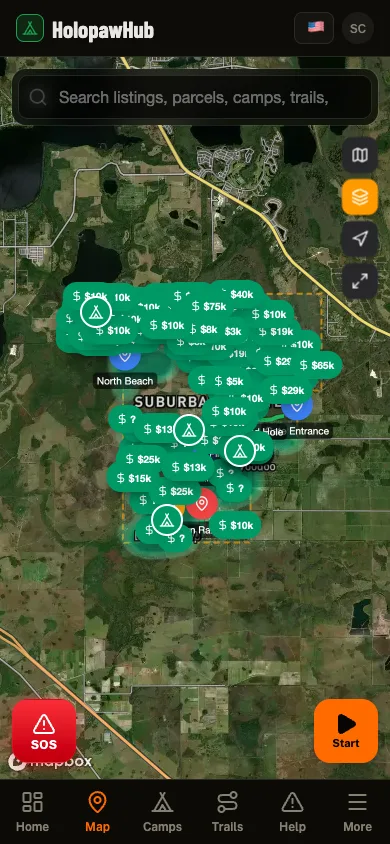
Need to see parcel boundaries on a map? The free Holopaw Hub app shows every parcel boundary overlaid on satellite imagery. Tap any lot to see owner details, record a trail, or check fire alerts. No subscription required.

See every parcel on a satellite map

The Holopaw Hub app shows every parcel boundary on satellite imagery. Tap any lot for owner details, fire alerts, and community features. Completely free.

Get the App. It's Free
In your pocket

Holopaw Hub, in your pocket.

Everything on this site plus the parts that only work in the field: parcel maps, GPS trail recording that keeps going with no signal, the neighbor feed, and fire alerts that reach you before the smoke does.

  • Public-land boundaries in your pocket. No subscription

  • Walk a boundary with GPS and see its real shape

  • Plan the route out to the parcel and save it

  • GPS tracking that keeps recording where signal never reaches

The Holopaw Hub app